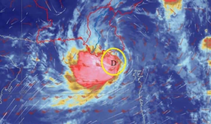
KARACHI – The Pakistan Meteorological Department (PMD) said the deep depression (DD, very strong low-pressure area) over Rann of Kutch, India, is likely to turn into a Cyclonic Storm (CS) by tomorrow, August 30, causing heavy-very heavy rains in Badin and other Sindh cities.
It said the deep depression has moved very slowly west-southwest during last 12 hours and now lies at around Latitude 23.7 N & Longitude 69.5 E at about 270km east/southeast of Karachi.
“The system is likely to move west/southwestwards & emerge into northeast Arabian Sea along Sindh coast by late night/ tomorrow morning. Due to favorable environmental conditions, sea surface temperature, low/moderate vertical wind shear and upper-level divergence, the system is likely to intensify further into a Cyclonic Storm (CS) by tomorrow and move initially in west/southwest direction,” read the forecast.
Under its influence, widespread rain/wind-thunderstorms with scattered heavy-very heavy to isolated extremely heavy falls likely in Tharparker, Badin, Thatta, Sujawal, Hyderabad, T.M Khan, T.A Yar, Matiari, Umerkot, Mirpurkhas, Sanghar, Jamshoro, Dadu & Shaheed Benazirabad districts & Karachi division till 31 August with occasional gaps.
Sea conditions are likely to remain rough/very rough with squally winds 50-60 Km/hour. The Met Office has advised fishermen not to venture into sea till 31 August.
PMD’s cyclone warning center, Karachi is monitoring the system and will issue the update accordingly. “The concerned authorities are requested to keep them abreast through PMD advisory,” it said.
Karachi Weather Update: Sindh capital to receive heavy rain today under new monsoon system


